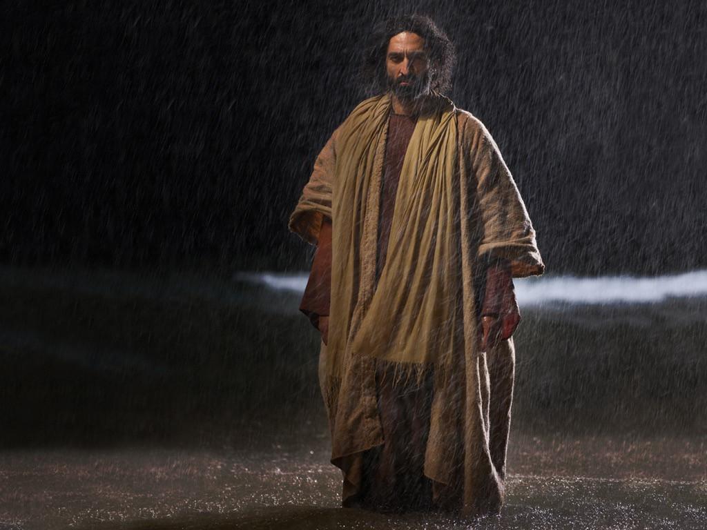
I do not believe Jesus1
performed any incontrovertible miracles. And indeed, for
some miracles recorded in the Bible, plausible
non-fantastical explanations are available, reflecting
possible embellishment by the ancient theologically
oriented writers. One such event is Jesus walking on water.
The event of Jesus walking on water near the town of
Bethsaida on the Sea of Galilee is recorded in
Mark 6:45-52,Matthew 14:22-34
and John 6:15-21.
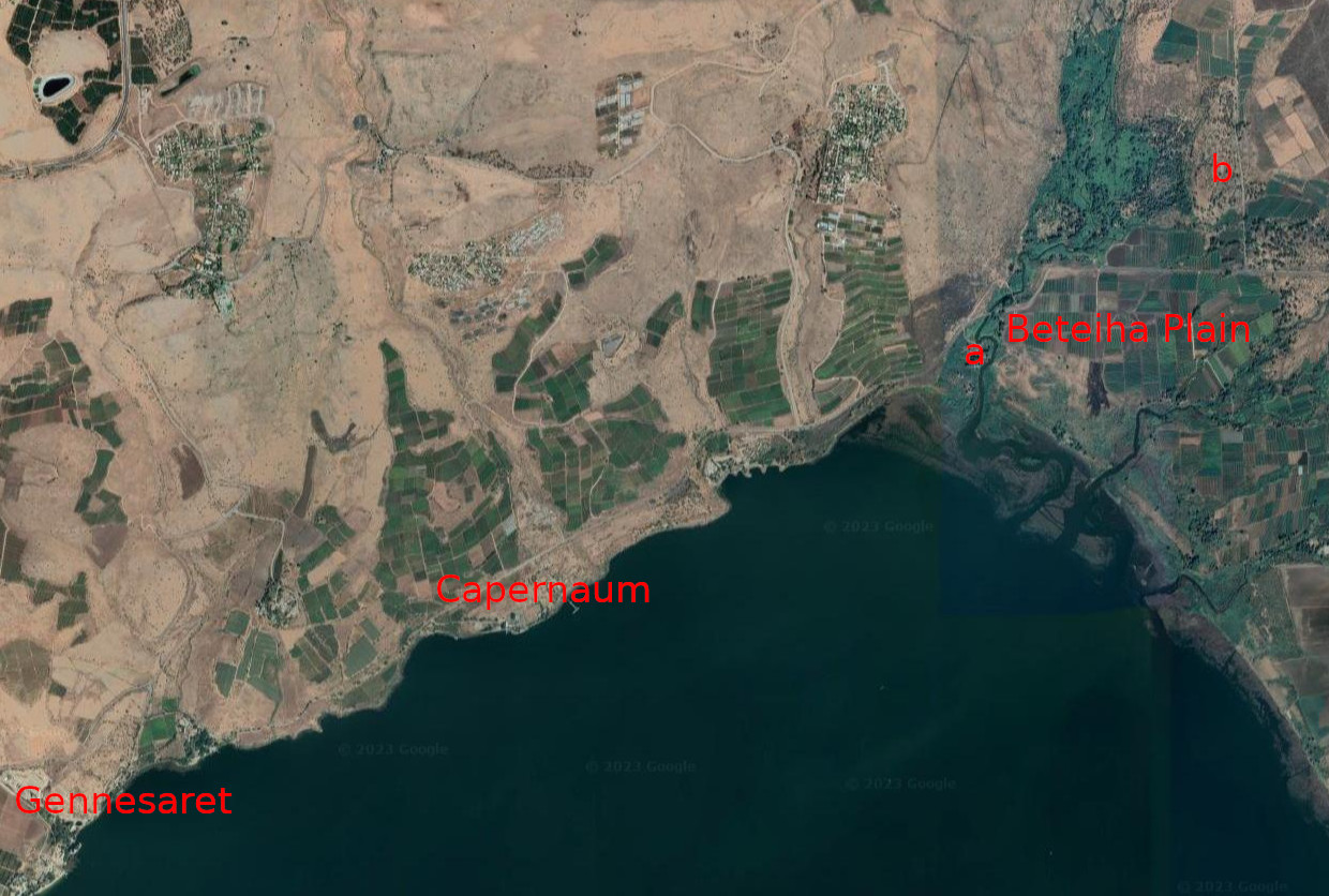
As an itinerant preacher during his ministry years,
Jesus would have spent much time in Galilee visiting
coastal towns such as Gennesaret, Capernaum and
Bethsaida, preaching on the lake's shores. On one such
occasion, he had been doing exactly that
(Mark 6:34).
We know that the location could not have been far from
the town of Bethsaida because it was late in
the day when Jesus instructed his disciples to
get into the boat and go on ahead of him to
Bethsaida while he dismissed the crowd(Mark 6:35-45).
Capernaum, for example, is about 4 km (2.5 miles)
from Bethsaida and there was a synagogue in Capernaum where
Jesus often preached
(Mark 5:22,Luke 7:5).
Figures [fig1]
and [fig2]
refer.
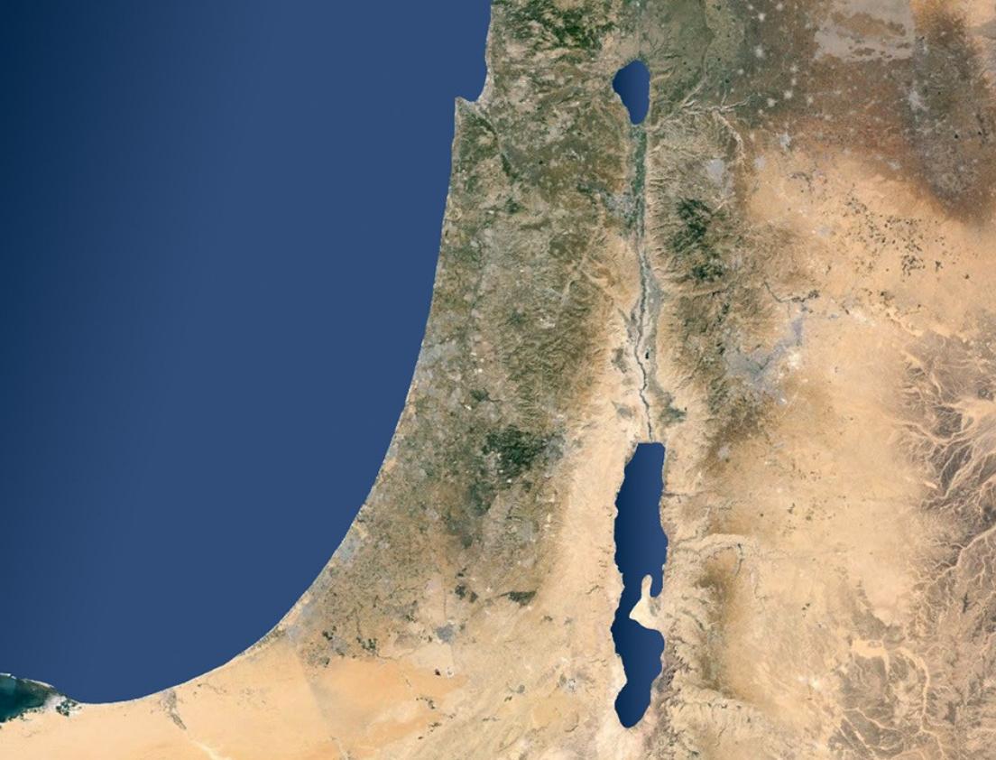
Figure
[fig1]:
Satellite map of Israel and surrounding regions
showing Jordan rift valley with the Sea of Galilee
to the north and the Dead Sea to the
south.[1]
Figure
[fig2]:
Satellite map of the northern shore of the
Sea of Galilee from Gennesaret on the left
to the Beteiha Plain on the right. As an
itinerant preacher, Jesus spent much time
in this region, visiting towns such as
Gennesaret, Capernaum and Bethsaida, giving
sermons on the lake's shores. The two leading
candidates for the site of the ancient town
of Bethsaida are also shown. They are el-Araj
(labelled
a)
and et-Tell (labelled
b).
What possible natural sequence of events could
have transpired after his disciples climbed into
their boat and began rowing to Bethsaida, such
that the sequence ultimately came to be mythologised
and immortalised by later religious scribes as the
Jesus-walking-on-water miracle?
Knowledge of the relative location of Bethsaida
during Jesus' time, of the topography near to the
disciples' intended destination (Bethsaida), and
of the flow characteristics of the Jordan river
offer valuable insights.
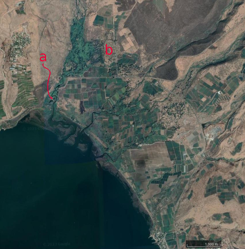
Two archaeological sites vie for the location
of the ancient town of Bethsaida during Middle
Classical Antiquity, as shown in Figure
[fig3].
The first site is el-Araj. It is located close to
the present northeastern shoreline of the Sea of
Galilee on the western edge of the Beteiha
Plain.2
The second site is at an ancient mound known as
et-Tell. The mound is located about 2.5 km (1.5 miles)
inland from the present northeastern shoreline,
also on the western edge of the Beteiha plain.
A panoramic view of the Beteiha Plain is shown in
Figure
[fig4].
Figure
[fig3]:
Close-up satellite map of the Beteiha Plain
located on the northeastern edge of the Sea
of Galilee. The Jordan river winds its way
down the western edge of the plain and empties
into the lake. An estuary system at the
mouth of the Jordan river is clearly visible.
The two candidate sites for the ancient town
of Bethsaida are el-Araj (labelled
a)
and the et-Tell mound (labelled
b).
Both are on the western edge of the plain close
to the river. The et-Tell site is about
2.5 km (1.5 miles) from the lake's present shoreline.
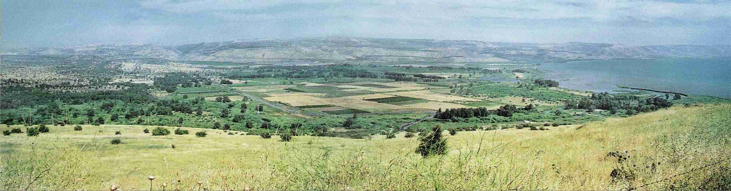
Figure
[fig4]:
A panoramic view overlooking the Beteiha Plain, facing
southeast.[2]
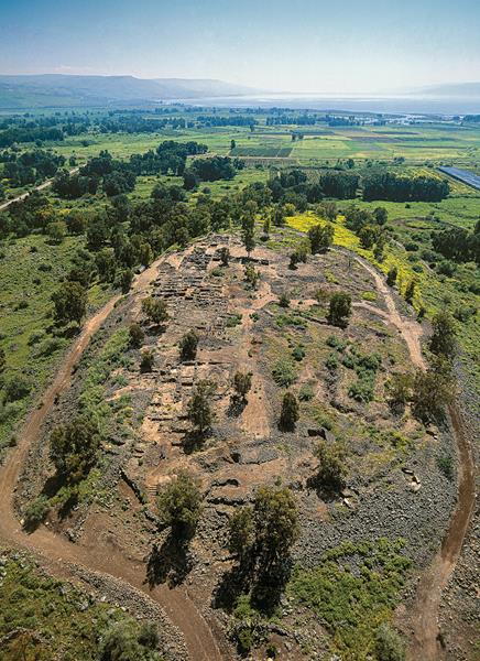
An archaeological excavation called the Bethsaida
Excavations Project led by professor Rami Arav has
been ongoing at the et-Tell site for about 34
years.[3][4]
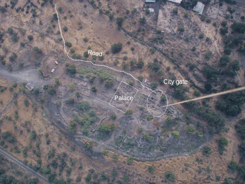
Figure
[fig5]
refers.
Figure
[fig5]:
Two aerial views of the ancient et-Tell mound
located near to the northwest shore of the Sea
of Galilee. The et-Tell mound is the most
likely location for the ancient town of
Bethsaida.[5][6]
There is sedimentologic and paleogeomorphic evidence
that the lake's shoreline was higher in antiquity
than it is today, and was therefore more inland.
The same evidence indicates that quiet waters existed
in antiquity in several locations in the western
Beteiha Plain and in the region of et-Tell in
particular. These quiet waters would have formed
an inlet or estuary near et-Tell not unlike the
present-day estuary system near
el-Araj.[7]
As part of this project, a geological team from the
University of Nebraska at Omaha completed an extensive
geomorphic survey of the western part of the Beteiha
Plain. The survey area included the land around both
the et-Tell mound and the el-Araj site. Fluvial and
lacustrine sediment data associated with the Jordan
river as it meanders its way across the Beteiha Plain
were obtained by sampling at various locations in the
plain. Data on sediment grain size, texture, color,
the presence of microfossils, gravel, clastics, organic
matter, pottery shards, and Roman glass were
collected.[8]
Subsequent stratigraphic analysis of these sampled
data revealed the following:
The present day alluvial plain was variously
covered with swampy water in antiquity, varying
in depth from, 0 to 2.4 meters.
An inlet, bay or estuary existed at or near et-Tell
in antiquity, not unlike the estuary shown in Figure
[fig6].
Recall that et-Tell is situated inland from the
present shoreline whilst still being in the
Beteiha Plain river delta.
This change to the shoreline and water level of
the Sea of Galilee confirmed earlier reports by
Shroder,[9][10][11][12]
Kraft,[13]
and Ben-Arieh.[14]
Strong seasonal flash flooding of the Jordan river
occurred. And the recession of the shoreline to
its present location was likely caused by
sedimentation due to this flooding, together with
known intermittent tectonic activity in the Jordan
Rift Valley.
Quoting from the Conclusion section of Baker's thesis:
The results have shown that areas of quiet and deep
(1 to 2 meters) water did indeed exist in antiquity
in the area of the western Beteiha Plain in several
locations. […] The presence of
pottery shards and glass in the sediments at depths
ranging from a few centimeters to 4 to 5 meters close
to et-Tell show clearly that an inlet or bay existed
deep into the Beteiha Plain in
antiquity. — Laura Baker[15]
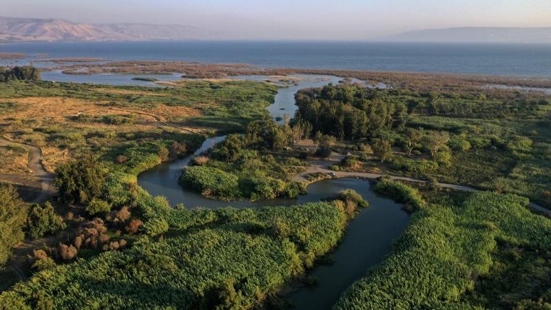
Figure
[fig6]:
South facing aerial view of the Jordan river
as it meanders through the Beteiha Plain close
to the river's mouth. The ancient el-Araj site
is situated on the bank of the river's oxbow.
A series of sandbars forming an estuary system
are visible behind el-Araj. During a flood, many
of the sandbars would become submerged in shallow
waters, forming new sandbanks. Jesus could have
been walking on one or more of these sandbanks,
creating an appearance of walking on the water's
surface. The photograph was taken in July
2021.[16]
Therefore, knowing:
1. that
the disciples were not far from Bethsaida when they
initially climbed into their boat and began rowing,
2. the
topography of the Beteiha Plain in antiquity,
3. that
there was an inlet or estuary system near
Bethsaida in antiquity,
4. that
the Jordan river undergoes flash flooding from
time to time, and
5. that
the disciples were indeed trying to make their
way to Bethsaida by boat, we are able to reconstruct
the following plausible sequence of events:
The disciples' boat was either approaching the
estuary waters at Bethsaida or it was already
there but not yet anchored.
A seasonal flood occurred.
The disciples' boat became engulfed in the rising
and rapidly flowing waters.
Jesus spotted them from the shore.
Realising their difficulty, walking in shallower
waters from sandbank to sandbar to sandbank, and
so on, he approached their boat.
But from the disciples' perspective, Jesus appeared
to be walking on water.
Jesus called out to them to jump out of the boat
because the waters were shallow where he was standing.
But they were afraid to do so.
In sheer frustration, Jesus might also have been
shouting at the waters, just like I am inclined to
shout at a strong headwind whilst on my bicycle.
Inevitably, the turgid waters calmed and subsided,
exactly as do the waters from all flash floods.
Which sequence of events is more plausible? The above
natural sequence which requires no fantastical miracle?
Or the one in which Jesus was quite literally walking on
the surface of water, magically displaying temporary
weightlessness in defiance of gravity, and summoning
supernatural command over the flow dynamics and mass
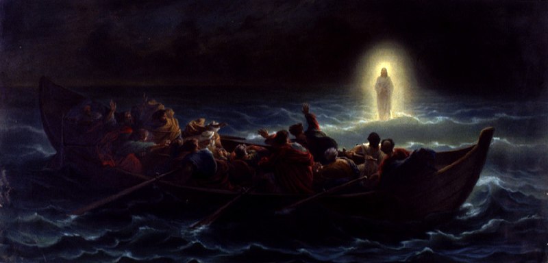
conservation of water, as depicted in Figure
[fig7]?
Figure
[fig7]:
Le Christ marchant sur la mer
(Christ walking on the waters) by Charles-Francois Jalabert
(1819–1901).[17]
Sometimes, the myths we pass down from generation to
generation may have little bearing on real events in
our histories. Perhaps they begin as entertaining
stories which become fantasies believed true. But at
other times, our myths derive from accounts of real
events whose mundane details become embellished and
exaggerated. In the end, it's the story which matters,
right?
1
I declare this to be my own work, entirely. In particular, no AI was used in any research, analysis, synthesis, writing, nor typesetting of this work. In short, AI was not recruited at any time in this work. Errors and inaccuracies are therefore proudly my own.
2
The Beteiha Plain is also called the Bethsaida Valley.
[7]Laura Baker.Sedimentologic and Paleogeomorphologic Character of the Western Beteiha Plain, Israel.Master of Arts (MA).University of Nebraska at Omaha.2000.Student Work 3393.Accessed 28 April 2021.https://digitalcommons.unomaha.edu/studentwork/3393
[9]JF Shroder.Deltaic and Lacustrine Sediment Isolation of Early Fishing Settlement, Jordan River and Lake Kinneret.Technical report.SBL International Meeting.Munster, Westphalia, Germany.1993.Page 75.
[10]JF Shroder and F John and R Arav and R Freund.Geomorphology of the Bethsaida archeological site on Lower Golan Heights and Lake Kinneret, Dead Sea---Jordan Rift Zone.Geological Society of America Abstracts with Programs.
():A-85,
1993.
[11]JF Shroder and M Inbar.Geologic and Geographic Background to the Bethsaida Excavations.In Rami Arav and Richard Freund, editor(s).Bethsaida Volume One: A City by the North Shore of the Sea of Galilee.1995.Thomas Jefferson University Press, Kirksville, Missouri.
[12]JF Shroder and MP Bishop and RJ Cornwell and M Inbar.Catastrophic Geomorphic Processes and Bethsaida Archaeology, Israel.In Rami Arav and Richard Freund, editor(s).Bethsaida Volume Two: A City by the North Shore of the Sea of Galilee.2000.Thomas Jefferson University Press, Kirksville, Missouri.
[13]JC Kraft and U Kayan and SE Aschenbrenner.Geological Studies of Coastal Change Applied to Archaeological Settings.In G Rapp and JA Gifford, editor(s).Archaeological Geology.1985.Yale University Press, New Haven, Connecticut.
[14]Y Ben-Arieh.Sea level fluctuations in the Sea of Galilee.Mada.9(6):307--312,
1956.